
THE 1424 portolan chart crafted by Venetian cartographer Zuane Pizzigano holds a significant place in global maritime history. This map not only illustrates the geographical understanding of the early 15th century but also introduces mythical islands that challenge conventional narratives of pre-Columbian exploration.
Significance in global maritime history
Pizzigano’s 1424 chart is a testament to the evolving knowledge of the world’s geography during the Age of Exploration. As a portolan chart, it was designed to aid sailors in navigation, detailing coastlines, ports, and sea routes. The map encompasses regions such as Western Europe, Northwest Africa, and expansive portions of the North Atlantic Ocean.
Notably, it depicts the Canary Islands with remarkable accuracy, showcasing eight islands including Alegranza, Roque del Este, and Fuerteventura. The inclusion of the Madeira Islands, recently discovered by the Portuguese between 1418 and 1420, underscores the rapid dissemination of exploratory findings among European cartographers.
More intriguingly, the chart portrays what appears to be the Azores archipelago, predating the official Portuguese discovery of these islands by several years. This suggests that knowledge of the Azores may have existed prior to their documented discovery, highlighting the map’s role in sharing and possibly influencing navigational knowledge.
Challenging conventional pre-Columbian history
Beyond its depiction of known territories, Pizzigano’s map introduces several mythical islands, most notably the Antillia group, which includes Antillia, Satanazes, Ymana, and Saya. The representation of these islands has sparked debates among historians regarding possible pre-Columbian trans-oceanic contact.
The presence of these islands on the map, especially given their detailed depiction and the inclusion of settlements, suggests that tales or perhaps even undocumented voyages may have informed Pizzigano’s work.
While the exact origins of these depictions remain uncertain, they challenge the notion that knowledge of trans-Atlantic lands was nonexistent in Europe prior to Columbus’s voyages. The map serves as a compelling artifact that invites reconsideration of the extent and nature of early exploratory knowledge.
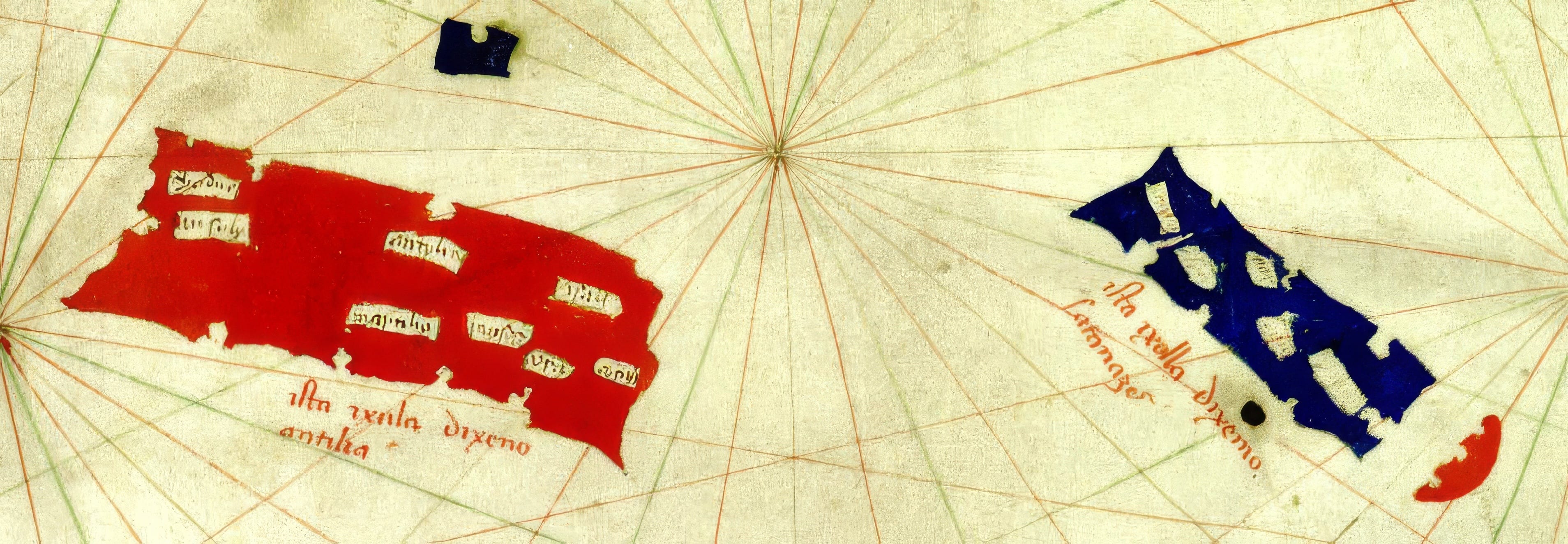
The Antillia group of islands
Central to Pizzigano’s chart is the depiction of the Antillia group, a quartet of islands situated in the North Atlantic Ocean, west of the Azores. Dominating this group are two large, rectangular islands: the red-coloured Antillia and, approximately sixty leagues to its north, the blue-hued Satanazes. Accompanying these are the smaller islands of Ymana, located about twenty leagues west of Antillia, and Saya, positioned north of Satanazes.
Antillia, often referred to as the “Island of Seven Cities,” is believed to derive its name from the Portuguese term “ante-ilha,” meaning “opposite island,” indicative of its position relative to Portugal. According to legend, following the Muslim conquest of Hispania in 714, seven Visigothic bishops fled across the Atlantic, establishing seven settlements on this island. Pizzigano’s map attempts to depict and name these seven settlements, lending credence to the legend’s influence on cartographic representations.
##CROSSOVER: Click here to read our main story, Zheng He: The forgotten discoverer of America?, at www.newasiacurrents.com
The island of Satanazes, translating to “Isle of Devils” in Portuguese, presents a more enigmatic origin. Some historians speculate that it may be linked to Norse sagas describing encounters with indigenous peoples, referred to as Skrælings, in regions like Greenland and Vinland. The nomenclature and depiction could reflect tales of these “devilish” inhabitants, suggesting a confluence of Norse narratives with Mediterranean cartographic traditions.
Ymana, possibly a transcription of “Ynsula Mam,” first appeared in the 1367 map by the Pizzigani brothers, relatives of Zuane Pizzigano. Its consistent inclusion in subsequent maps indicates a sustained belief in its existence. Saya, the northernmost of the group, remains obscure in origin, with limited historical references to elucidate its significance.
The Antillia group captivated the imagination of cartographers and explorers throughout the 15th century. Their consistent depiction across various maps underscores the blend of myth and reported sightings that influenced navigational charts of the era. While these islands were later proven to be nonexistent, their inclusion in Pizzigano’s map reflects the period’s exploratory zeal and the interweaving of legend with cartographic science.
In conclusion, Zuane Pizzigano’s 1424 map stands as a pivotal document in maritime history. It encapsulates the geographical knowledge of its time, challenges modern perceptions of pre-Columbian exploration, and vividly illustrates the mythical narratives that shaped the cartographic landscape of the Age of Discovery.
Source: Written with information from Wikipedia (https://en.wikipedia.org/wiki/Zuane_Pizzigano, March 31, 2025)
All articles, opinions, and events featured in PostScript NAC represent the views of the interviewees, individual writers and contributors, and do not necessarily reflect those of PostScript NAC. While we strive to ensure all information on this post is accurate, complete, and current, PostScript NAC is not responsible for any errors, omissions, or outdated content.